The ground segment of the Belarussian Space System for Earth Remote Sensing (BSSERS) integrates the existing satellite signal reception, storage and processing facilities within one unique and integral system.
The ground segment of the BSSERS is destined to solve the following tasks:
- - To control the Belarusian Satellite (BS) from the TT&C (Telemetry, Tracking and Command) ground station at Pleschinitsy town.
- To analyze the technical conditions of the BS onboard systems on the basis of the TT&C station X-band telecommunication link and the mission data downlink channel.
- Acceptance, revision and coordination of user requests for ERS data;
- Planning and issuing of BS collection tasking according to available customer requests;
- ERS data reception from different satellites: BS, Canopus-V №1, Монитор-Э, Метеор-М №1, NOAA, Terra and other prospective satellites;
- Remote sensing data storage;
- Quality assessment, suitability test, pre-processing and thematic processing of Earth Observation data;
- Delivery of processed remote sensing data to customers according to their requests.
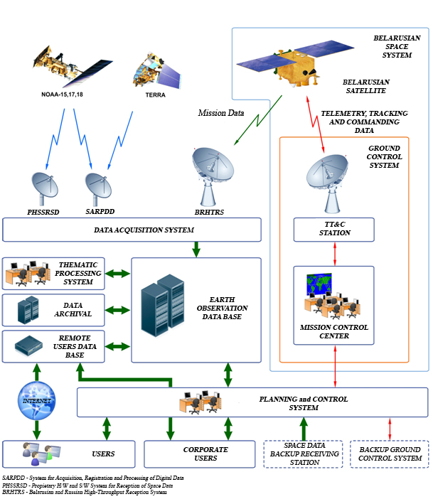
The BSSERS ground segment includes the Belarusian Ground Control System (BGCS) and the Belarusian Ground Acquisition, Processing and Satellite Data Dissemination System (BGAPSDDS).
The Belarusian Ground Control System was developed by the Federal State Unitary Enterprise "All-Russian Scientific Research Institute of Electromechanics (Scientific Production Enterprise NPP VNIIEM)" and consists of the Mission Control Center (MCC) and the TT&C station.
The Mission Control Center or Operations Control Center manages the Belarusian Satellite flight and determines the operational status of the Belarusian Satellite and its onboard subsystems, i.e. allows to solve the following tasks:
- to plan the operation of the onboard and ground equipment in order to assure an efficient use of the Belarusian Satellite;
- to determine the orbital parameters of the satellite motion on the basis of the BS navigation system data processing and the current measurements of the navigation parameters at the TT&C station;
- calculation and generation of the navigation and ballistics information, TT&C and mission data acquisition antenna pointing;
- generation of commands and program information to control the BS Onboard Digital Computer System (ODCS) and relevant response transmissions back to the TT&C station;
- reception and processing of telemetric (monitored) information;
- analysis and displaying of the Belarusian Satellite health and status.
The Telemetry, Tracking and Command Station assures the following:
- receives information from the MCC for its own control and to control the BS;
- establishes communications sessions with the BS;
- transmits commands and program information to BS ODCS, receives delivery error codes to ensure delivery of packets across the communication channel;
- reception of BS telemetric information, its relevant pre-processing, storage and transmission to the MCC;
- conduction of flight path measurements, pre-processing of the received flight path information and its further transmission to the MCC;
- checks of onboard and ground timing and transmission of the obtained results to the MCC;
- conduction of functional check-outs, generation of a general report on TT&C hardware health and its transmission to the MCC.
The Belarusian Ground Acquisition, Processing and Satellite Data Dissemination System was implemented on the basis of the following integrated and technological systems:
– Data Acquisition Systems (DAS);
– BSSERS Planning and Control System;
– System for Thematic Processing of Earth Observation Data;
– Data Repository of Digital Terrain Elevation Data (DRDTED) with archival information;
– BSSERS Corporate Local Area Network (LAN).
The Data Acquisition System includes three stations, which allows the acquisition and recording of the BS data flow, as well as from such satellites as Canopus-V №1, Monitor-E, Meteor-M №1, NOAA, Terra and other prospective satellites.
The incoming Earth remote sensing data are real-time recorded on the hard disks of the DAS.
The acquired raw data passes through LAN communication channels and enter the pre-processing system for generation of the relevant quicklooks and its relevant storage in the DRDTED.
The BSSERS Planning and Control System assures the realization of native and foreign user requests as well as planning the intended performance of BS and the control of the BSSERS components.
The BSSERS Planning and Control System is destined to the following tasks:
– acquisition, user requests pre-processing and delivery to users of Earth Remote Sensing data and its relevant processing results;
– checking request compliance/feasibility and analysis of requests progress within the corresponding BSSERS departments;
– generation of cloud cover forecasts for the image acquisition areas of interest;
– tasking the satellite instrument (payload) and the satellite Mission Data Radio Communication Link (MDRCL), generation of operation plans for the receiving stations;
– Reception of data on space vehicle (SV) status, its processing and analysis for planning the SV mission performance;
– planning the operation of the DAS for acquisition of low resolution satellites data;
– delivery of operation schedules to DAS and receipt of relevant executed task reports;
– delivery of thematic processing tasks to the Thematic Processing System and receipt of relevant executed task reports;
– collection of information on the factual status of hardware and software on a day-to-day basis and equipment technical maintenance plans once per month.
The System for Thematic Processing of Earth Observation (EO) Data is destined to process space information from different EO satellites and assures the execution of the following tasks:
a) Technological functions – used directly during the image acquisition process, the classification and storage of information, as well as for the processing of EO data from the BSSERS:
– BS instrument calibration;
– Recovery and photogrammetric preprocessing of the received BS mission data for generation of digital images of different processing levels and image meta data with indication of the acquisition date, resolution, processing level, coordinates of the rectangular image edges and so on;
– near real time reflectance modification of the terrain to be acquired (albedo values for correction of the BS instrument acquisition mode;
– near real time cloud cover calculation and determination of its borders during user requests selection and flight tasking;
– multifunctional processing of digital images (quality enhancement, chunking, features highlighting, etc.);
– BS mission data quality assessment;
– mapping support of the BSSERS systems.
b) thematic tasks – different kinds of processing in the interest of institutions and organizations:
– near real time monitoring and detection of temperature anomalies on the territory of Belarus for the Ministry of Emergency Situations and the Ministry of Forestry;
– forest tenure activities (near real time monitoring of changes, tree felling, logging, windfall timbers, burned areas, determination of forested areas flammability classification);
– cadastral activities (land use, urban planning);
– determinate the conditions of dried wetlands and hydraulic engineering facilities;
– long-term forecasting of grain crop yields.
The Data Repository of Digital Terrain Elevation Data (DRDTED) with archival information is destined to house, classify, account and analyze the near to real time and long term stored digital terrain elevation data (DTED); to search for spatial and temporal attributes, as well as other metadata parameters; to provide DTED to dedicated local and remote information systems for its corresponding processing and handles:
– BS raw data;
– BS flight strip acquisitions;
– processed BS images;
– foreign satellites images;
– digital maps;
– thematically processed data.
The BSSERS Corporate Local Area Network (LAN) was implemented to arrange the digital information exchange among the BSSERS ground infrastructure components and to provide the relevant communication channel to remote users.
